For Architects: Precision for Design
Our advanced laser scan surveying offers architects total confidence through pin-point accuracy for every project. By delivering precise existing-condition data and AutoCAD-ready drawings in DWG or PDF formats, we support seamless refurbishments and complex extensions. We provide the vital technical detail needed for heritage site planning and high-quality design.
Refurbishment Accuracy
Capture intricate structural details and MEP services with sub-millimetre precision for seamless integration of new designs.
Heritage & Conservation
Non-intrusive scanning of historic fabrics, preserving delicate structures while creating highly detailed archival records and restoration plans.
AutoCAD-Ready Outputs
Survey drawings can be supplied as accurate, fully editable DWG files, giving architects a reliable set of existing plans to work from. These can be used directly in AutoCAD to develop proposed layouts, extensions, refurbishments and planning drawings.

Technical Overview
Scan Accuracy
Deliverables
File Formats
Capture high-precision data with a 2-4mm point accuracy, ensuring a reliable digital twin for architecture, heritage, and engineering projects across the UK.
We convert point cloud data into clean, well-layered AutoCAD drawings so your team can move straight into design. Surveys are issued as DWG files with clear layering, line weights and annotation ready for your office standards.
We provide industry-standard deliverables including DWG files for AutoCAD and detailed PDFs, perfectly suited for professional architectural project workflows.
Architectural Case Studies
Precision in Practice


Heritage Refurbishment
Our Leica BLK360
Designing in Context
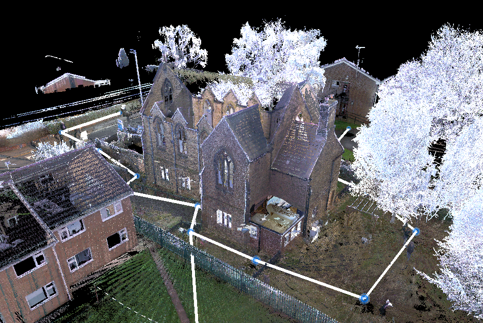
Site survey for a disused church, bringing life back to a prominent community landmark. Capturing high angular elevations and non-orthogonal walls. For an architectural client to create new dwellings for a private client.
Our Leica BLK360 captures high‑density point clouds with millimetre-level accuracy, having 4 mm accuracy at up to 10 meters. Ideal for detailed measured surveys and complex existing buildings.
Laser scanning captures the surrounding street scene in precise 3D, recording neighbouring buildings, levels and key features. This gives you reliable context for massing, daylight, views and townscape so you can design with confidence.
The Developer’s Workflow
01
02
03
04
Briefing & Feasibility
On-Site Scanning
CAD/BIM Processing
Scalable Delivery
We define the specific due diligence requirements, derisking the clients acquisition by identifying structural constraints and site potential early on.
Non-intrusive 3D laser scanning on-site captures millions of data points rapidly, providing a total understanding of existing buildings without disruption.
The precise point cloud is processed into AutoCAD-ready DWG or Revit BIM models, maximising development potential through accurate spatial data.
Final delivery of professional technical packs speeds up planning and design, providing clients with reliable documentation for future works.
Our Partners:
Public sector procurement and framework specialists supporting efficient, compliant housing and regeneration projects across the North.
Digital design support platform connecting you with on-demand architectural and planning experts.
Public sector buying organisation providing compliant procurement routes for surveying and professional services.
Ready to Start?
Request Your Custom Architectural Quote
Book a RICS-certified laser scan survey today. Our expert team provides the accurate point clouds and BIM-ready models you need to drive your project forward with confidence.